|
T+19 (June 17, 2020) Navigation Report; Starting Point. Rutherford Shelter mile 1336.0 Destination: "Secret Shelter" mile 1345.9 Travel Log: 11:50 Break Camp 12:05 Dutch Shoe Rock (mile 1336.3) 12:15 viewpoint (mile 1337.3) 1:20 Sawmill Pond view (mile 1337.9) 1:50 High Point State Park (mile 1338.9) 2:45 Observation Tower (mile 1340.0) 3:00 NS Highest Point Monument 4:45 Pastures (mile 1343.1) 5:10 Pond (mile 1343.3) 5:30 Ferguson Road (mile 1343.8) 5:45 Gemmed Road (mile 1344.5) 5:55 Streams (mile 1345.3) 6:10 Goodridge Road (mile 1345.5) 6:15 Pond (mile 1345.7) 6:25 "Secret Shelter" (mile 1345.9) Daily Mileage 9.9 Total Mileage: 193.3 Commander’s Report: Last night, just as I was nodding off, I was awoken by the amazing calls of a bird. As I lay there listening I could hear others answering it from the distance. I haven't a clue what kind of bird it was, but together those little buggers enveloped me in a sea of song. One individual would make rapid fire calls (1/sec) constantly for a minute or more, then go quiet as their friends took up the call. This went on for hours. In fact, when I fell asleep, around 1AM, they were still going at it. After about 30 minutes of this calling, heard one call steadily growing closer. It got close enough that I figured I could capture it in my microphone, so I made a video of the inside of my tent. The cheeky bastard proceeded to continue getting closer to my tent, until it descended from the trees and decided to check out the fire pit. It made one final series of calls from the fire pit (15' away) that lasted several minutes. By that time, I was ready and was able to capture nearly 2 minutes of the calls on tape, let's give myself a challenge: upload just the audio of this. (If you're reading this and there's no audio, I flunked this challenge.) [Ed. Note: sad trombone. I failed. The bird is a type of whip-poor-will. <ht @halvorz>] In the morning I rose from my slumber around 7AM and proceeded with the typical morning routine. I wrote up the previous 2 days worth of travels and got them prepared for posting, but poor cell service precludes internet access at the moment. They'll get posted eventually. Yesterday, I noticed that I was experiencing some uncomfortable rubbing on my right shoulder. So, before I set off today I was determined to get to the root cause of that problem and solve it. It turned out that the right shoulder strap needed some readjusting. As it had been 3+ months since I set it up the first time, I had to relearn how to accomplish this all over again. It only took an hour and a half. Time well spent, I didn't have any problems with it during today's hike. Shortly after getting back to hiking, the trail goes over Dutch Shoe Rock. I really don't get the name. I don't think it looks particularly like a Dutch Shoe myself. 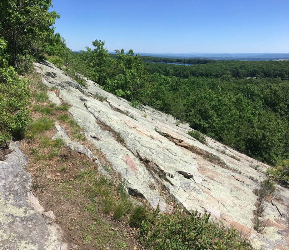 Dutch Shoe Rock Not much of a view of Sawmill Pond in the summer. Oh well, its an excuse to come back in the winter.  Trees About 2 miles north of that "viewpoint" is an observation deck. There were some sweet views from here.  View from the observation platform But let's be honest here: The reason this deck was built is because it is a high point directly adjacent to New Jersey's highest point, which has a huge obelisk erected up on the tip of mountain.
That monument is off on a side trail that. goes up to the top. Saw lots of day hikers going up, even though the trail is quite a steep ascent straight to the top. It's a good thing I did, otherwise I wouldn't have captured this masterpiece. I may frame this one up after all is said and done.  This came out better than expected The monument is a memorial to war veterans, and was build in the 1930's. Unfortunately, the observation platform inside the obelisk is closed due to COVID.  War veterans memorial About 3 miles north from the highest point the trail runs along the outskirts of hay fields. To start this part of the journey, you have to jump a fence line. Or you used to, until someone ripped up the fence. Let's hope this happened with the owner's permission.  Fence bridge The fields really reminded me of my childhood in rural upstate NY. Specifically, playing in similar fields with friends during summer vacation. The farmers never said anything about us cutting "forts" into their crop, but I bet they were cursing us during harvest. In between the fields, the trail cuts through scrubland in between fields.  He shines his light upon hedgerow cleavage Sometimes, you end up with this claustrophobic strip in between fields and the trail runs down the middle of that.  Between two hedgerows Between two hedgerows In one of the fields, I met this fantastic beast. A nice little wood turtle sharing the trail with me.  Wood turtle On the road heading up to Jim Murray shelter (AKA the "secret shelter" as it's not recognized by the ATC) I managed to finally get a pic of a deer. Took me long enough.  White tailed deer I caught Jim and caretaker Zen Dragon just as Jim was leaving. Nice amenities at this shelter! You have every essential you can imagine: shower, electricity, and laundry (DIY). Plus they had ducks, chickens, and Jake. Jake is a loveable donkey with a penchant for human food. he way he begs like a dog for a handout is amazing to me I never would have suspected donkeys would like cooked oatmeal, but I guess that's just a mushy version of donkey food. Makes more sense now.  Jake the donkey Just after I arrived at the shelter, another hiker showed up, French Press. A nice guy with a very German demeanor. I swear the man's pack is a bag of holding. (For you non-D&D nerds out there, a bag of holding can fit things of any size into them. Think of the black hole prop Wile E. Coyote uses and trains run out of resulting hole.) Had a fantabulous sunset tonight. I know pictures never do sunsets justice, but here it is anyway.  Sunset over the farm
0 Comments
Leave a Reply. |
About Me
Archives
July 2020
Categories |

 RSS Feed