|
T+19 (June 17, 2020) Navigation Report; Starting Point. Rutherford Shelter mile 1336.0 Destination: "Secret Shelter" mile 1345.9 Travel Log: 11:50 Break Camp 12:05 Dutch Shoe Rock (mile 1336.3) 12:15 viewpoint (mile 1337.3) 1:20 Sawmill Pond view (mile 1337.9) 1:50 High Point State Park (mile 1338.9) 2:45 Observation Tower (mile 1340.0) 3:00 NS Highest Point Monument 4:45 Pastures (mile 1343.1) 5:10 Pond (mile 1343.3) 5:30 Ferguson Road (mile 1343.8) 5:45 Gemmed Road (mile 1344.5) 5:55 Streams (mile 1345.3) 6:10 Goodridge Road (mile 1345.5) 6:15 Pond (mile 1345.7) 6:25 "Secret Shelter" (mile 1345.9) Daily Mileage 9.9 Total Mileage: 193.3 Commander’s Report: Last night, just as I was nodding off, I was awoken by the amazing calls of a bird. As I lay there listening I could hear others answering it from the distance. I haven't a clue what kind of bird it was, but together those little buggers enveloped me in a sea of song. One individual would make rapid fire calls (1/sec) constantly for a minute or more, then go quiet as their friends took up the call. This went on for hours. In fact, when I fell asleep, around 1AM, they were still going at it. After about 30 minutes of this calling, heard one call steadily growing closer. It got close enough that I figured I could capture it in my microphone, so I made a video of the inside of my tent. The cheeky bastard proceeded to continue getting closer to my tent, until it descended from the trees and decided to check out the fire pit. It made one final series of calls from the fire pit (15' away) that lasted several minutes. By that time, I was ready and was able to capture nearly 2 minutes of the calls on tape, let's give myself a challenge: upload just the audio of this. (If you're reading this and there's no audio, I flunked this challenge.) [Ed. Note: sad trombone. I failed. The bird is a type of whip-poor-will. <ht @halvorz>] In the morning I rose from my slumber around 7AM and proceeded with the typical morning routine. I wrote up the previous 2 days worth of travels and got them prepared for posting, but poor cell service precludes internet access at the moment. They'll get posted eventually. Yesterday, I noticed that I was experiencing some uncomfortable rubbing on my right shoulder. So, before I set off today I was determined to get to the root cause of that problem and solve it. It turned out that the right shoulder strap needed some readjusting. As it had been 3+ months since I set it up the first time, I had to relearn how to accomplish this all over again. It only took an hour and a half. Time well spent, I didn't have any problems with it during today's hike. Shortly after getting back to hiking, the trail goes over Dutch Shoe Rock. I really don't get the name. I don't think it looks particularly like a Dutch Shoe myself. 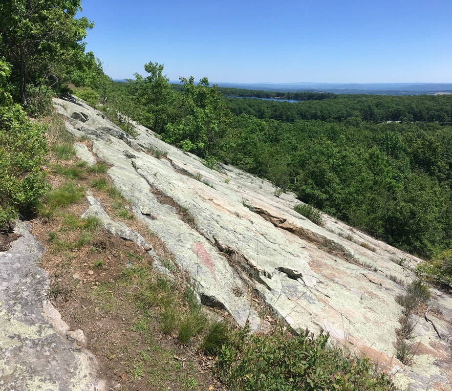 Dutch Shoe Rock Not much of a view of Sawmill Pond in the summer. Oh well, its an excuse to come back in the winter.  Trees About 2 miles north of that "viewpoint" is an observation deck. There were some sweet views from here.  View from the observation platform But let's be honest here: The reason this deck was built is because it is a high point directly adjacent to New Jersey's highest point, which has a huge obelisk erected up on the tip of mountain.
That monument is off on a side trail that. goes up to the top. Saw lots of day hikers going up, even though the trail is quite a steep ascent straight to the top. It's a good thing I did, otherwise I wouldn't have captured this masterpiece. I may frame this one up after all is said and done.  This came out better than expected The monument is a memorial to war veterans, and was build in the 1930's. Unfortunately, the observation platform inside the obelisk is closed due to COVID.  War veterans memorial About 3 miles north from the highest point the trail runs along the outskirts of hay fields. To start this part of the journey, you have to jump a fence line. Or you used to, until someone ripped up the fence. Let's hope this happened with the owner's permission.  Fence bridge The fields really reminded me of my childhood in rural upstate NY. Specifically, playing in similar fields with friends during summer vacation. The farmers never said anything about us cutting "forts" into their crop, but I bet they were cursing us during harvest. In between the fields, the trail cuts through scrubland in between fields.  He shines his light upon hedgerow cleavage Sometimes, you end up with this claustrophobic strip in between fields and the trail runs down the middle of that.  Between two hedgerows Between two hedgerows In one of the fields, I met this fantastic beast. A nice little wood turtle sharing the trail with me.  Wood turtle On the road heading up to Jim Murray shelter (AKA the "secret shelter" as it's not recognized by the ATC) I managed to finally get a pic of a deer. Took me long enough.  White tailed deer I caught Jim and caretaker Zen Dragon just as Jim was leaving. Nice amenities at this shelter! You have every essential you can imagine: shower, electricity, and laundry (DIY). Plus they had ducks, chickens, and Jake. Jake is a loveable donkey with a penchant for human food. he way he begs like a dog for a handout is amazing to me I never would have suspected donkeys would like cooked oatmeal, but I guess that's just a mushy version of donkey food. Makes more sense now.  Jake the donkey Just after I arrived at the shelter, another hiker showed up, French Press. A nice guy with a very German demeanor. I swear the man's pack is a bag of holding. (For you non-D&D nerds out there, a bag of holding can fit things of any size into them. Think of the black hole prop Wile E. Coyote uses and trains run out of resulting hole.) Had a fantabulous sunset tonight. I know pictures never do sunsets justice, but here it is anyway.  Sunset over the farm
0 Comments
T+18 (June 16th, 2020) Navigation Report: Starting Point: Gren Anderson Shelter (1327.6) Destination: Rutherford Shelter (1336.0) All AM Brown Headed Cow Bird 11:00 Break Camp (mile 13276) 11:20 Pond (mile 1328.0) 12:20 Sunrise Mountain (mile 1330.9) 3:05 Pre-Gas line lookout (mile 1334.7) 3:10 Gas line (mile 1334,7) 5:00 Rutherford Shelter (1336.0) Daily Mileage: 8.4 Total Mileage: 187.4 Commander’s Report: Woke up this morning at about 6 to the sound of a faucet dripping. Or at least that is what my brain interpreted the noise that roused my slumber. In truth, it was the vocalizations of a male brown headed cow bird. I indulged my OCD of needing to identify the bird responsible. Through googling, I thought it was probably a brown headed cow bird, but I couldn't spot the booger making the calls. I spent quite a bit of time trying to catch him in the act! It wasn't until I had put on my pack and was going through my pre-hike mental checklist when the little chap unveiled himself. He flew to the lowest branch, stared me in the face, and made a series of vocalizations. He didn't leave until I reached for my phone. I'd like to think that interaction went thusly: Bird: thanks for the jolly fun game of hide and seek earlier. Me: My pleasure. Thanks for the curtain call! Bird: <<Blushes>> Me: Mind if I fanboy and get a picture of you? Bird: Don't push your luck! <<FLIES OFFS>> SCENE Anyway, Dr. Google says that brown headed cowbirds greatly prefer to live at forest boundaries. I was nowhere near a boundary, which is why I was so suspicious without a visual ID. Dr. Google also said that the fact this species is a bit perplexing. You see, cow birds are brood parasites. The females lay their eggs in the nests of other birds. Their offspring are raised by foster parents (if you pardon the personification). How then do the young males know to sound like a cow bird and not, say, a robin? How indeed. Dr. Google only posed the question, he didn't answer it. I felt amenable to a wild goose (or brown headed cowbird) chase as I only have 8.4 miles of hiking planned for today. My typical pace is about 2 MPH and has been fairly consistent across terrains. Thus, I have 4-1 hours of hiking planned. I know this pacing is good for me, but it's hard to suppress my inner drive to push my body to the max. Bonus: it yielded 2 pages of content. First checkpoint today, a small pond that the guidebook says is stagnant and warns against using it as a water source. Having seen it, I can't believe the guidebook actually feels the obligation to tell us that. IT'S JET BLACK! It’s the Appalachian Trail, water sources are plentiful. I can’t imagine anyone desperate enough to look at that and dive right in!  Do not drink if the “water” is black. Thanks for coming to my TED talk. I think the picture doesn't quite do justice to how striking blue the reflection of the sky was on the surface of that dark pond. Oh well. Nearly 3 miles north of the pond is the summit of Sunrise Mountain. Here, there's a large pavilion and views into both the Poconos and Catskills. (I think, should check that) A couple tenths of a mile down the trail is a parking lot with a great viewing platform. 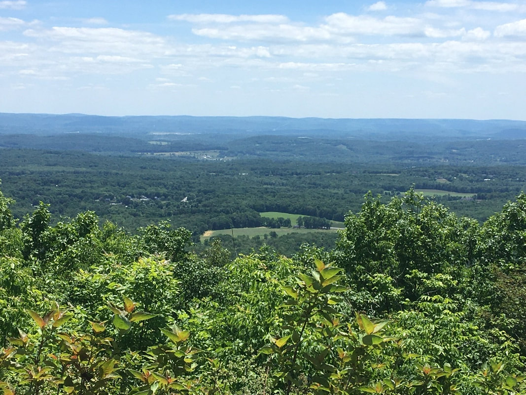 Sunrise Mountain lookout  The view from under the shade of the pavilion Nearly 4 miles north of Sunrise Mountain the trail is bifurcated by a pipeline. This provides a nice vantage point.  All I notice in this image is the man-made scar upon the earth. Though it is striking how differently one can see the world by just changing perspectives.  Problem solved. (Not really) For my money though, I preferred the view from an overlook a hundred or so yards before the gas line. (The scars of man are hidden from view here.) Which do you guys prefer? 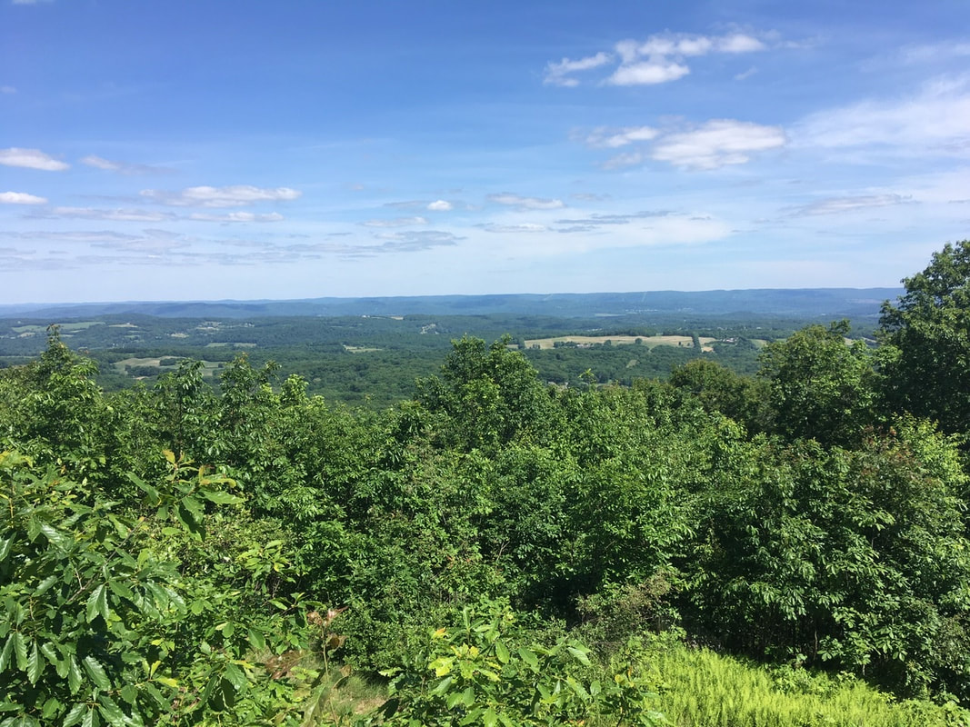 Essentially the same landscape. Totally different impressions. A mile and a half after the pipeline I rolled up on Rutherford Cabin. The side trail is about a half mile long, so it was relieving to catch this view of the cabin off to the left.  Rutherford Shelter as first observed from the access trail Yes, I'm tenting at a shelter. Yes, even though I'm alone here tonight. I can be Lawful Good about some things. 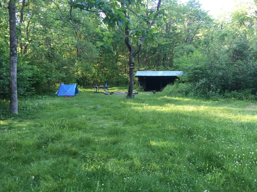 Rutherford Shelter with my erect tent. While prepping dinner, a deer ran out from the woods and down the trail to the AT. Alas, I wasn't able to be Quick Draw McGraw with my phone. Oh well, please accept this picture of a bunny instead. She was a bit more photogenic. It turns out that Mrs. Bunny has a family! I went out to pee around 10pm and there were about 5 sets of eyes peering back at me. And that is your moment of zen. 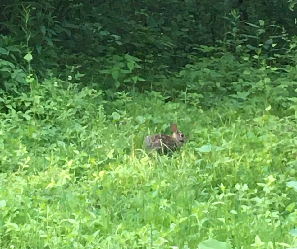 Little fluffy bunny T+17 (June 15, 2020) Navigation Report: Starting Point : Campsite (mile 1312.7) Destination: Gren Anderson Shelter (mile 1327.6) Travel Log: 10:00 Break Camp (mile 1312.7) 10:05 Break Camp x2 10:20 Fairview Lake viewpoint (mile 1313.5) 10:30 Black rat shake 10:35 Blue Mountain Lake Rd. (mile 1313.9) 11:05 "Beaver Bog" (mile 1315.2) 11:20 Crater Lake overlook (mile 1315.6) 12:15 Southeast view (mile 1317.8) 12:35 Stream-water refill (mile 1318.3) 1:00 Rattlesnake Mountain (mile 1318.7) 1:45 Blue Mountain (mile 1320.2) 2:40 Dry beaver pond (mile 1321.4) 3:25 Culver Lake viewpoint (mile 1323.3) 5:15 View before fire tower (mile 1326.2) 5:20 Culver Fire Tower (mile 1326.5) 5:35 Wood frog 6:00 Stream (mile 1327.5) 6:15 Gren Anderson Shelter (mile 1327.6) Daily Mileage: 14.9 Total Mileage: 179 Commander’s Report: It didn't take long to have to modify my plans. Yesterday's lower than planned mileage means 4.5 miles more to do today. Additionally, the blog posts from T+15 and T+16 needed to get wrapped up. Luckily I woke up raring to go at 5-30. I spent the next 3.5 hours putting those together and uploaded. Add in an extra hour to pack and it means I didn't get out of camp until 10AM. One would think that with all that time in the morning that I would be able to get my shit together before getting on the trail. Apparently not! I initially forgot to take my hiking poles, so had to return for them. Once properly on the trail, it didn't take me long arrive at the first (of many) viewpoint on the day's hike. I wasn't looking for a view point, but I couldn't help and go down the well worn side trail to this vantage point. The view of Fairview Lake off to the southeast below is quite worth the several hundred yard detour!  The approach to Fairview Lake overlook let’s you know it’s going to be good! 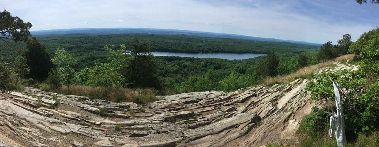 Fairview Lake overlook Quite soon after getting back on the trail I encountered my first smol fren of the day. I was lost in thought and apparently not paying enough attention at the trail ahead of me, so I nearly skewered a black rat snake with the tip of my hiking pole. Note to self: pay attention for danger noodles in the future! 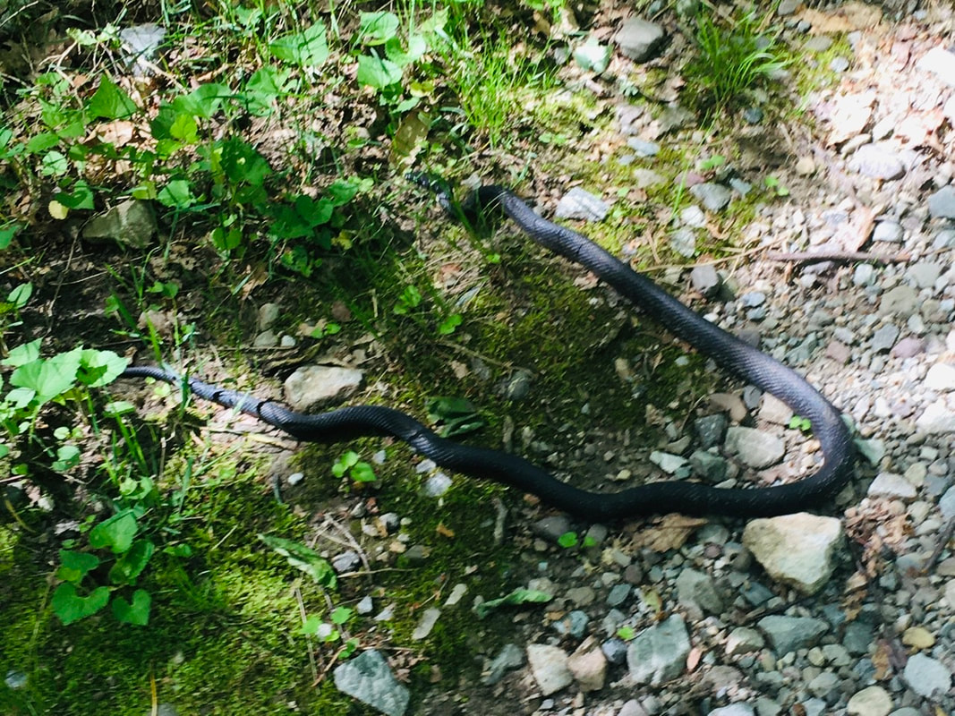 Black rat snake exiting stage left About a half an hour after the nope rope encounter I came upon what the guide lists as a "beaver bog". The beavers must have packed up and moved to Beverly Hills, because their bog was bone dry. The dried up lake bed certainly had an eerie quality to it.  For sale: one beaver pond, slightly distressed A short distance northward, where the trail runs around Crater Lake, I passed by a view point that looks out northwest at a point of high ground. Unfortunately, no views of the lake off to the east.  Crater Lake viewpoint About 2 miles north from that view point is a place with a southeast view. This is past Crater Lake, so no water views. I think the trees do a good enough job of making for striking views.  View to the northwest from viewpoint at mile 1317.8 About a half mile north of this view point I stopped at a stream to replenish my water supply. It's already that time of year where the heat makes my mouth feel like I ate a mouthful of sand. I can't imagine hiking through the desert...that would suck big time! A half mile north from the stream is the top of Rattlesnake Mountain. This provides nice views off to the northwest. 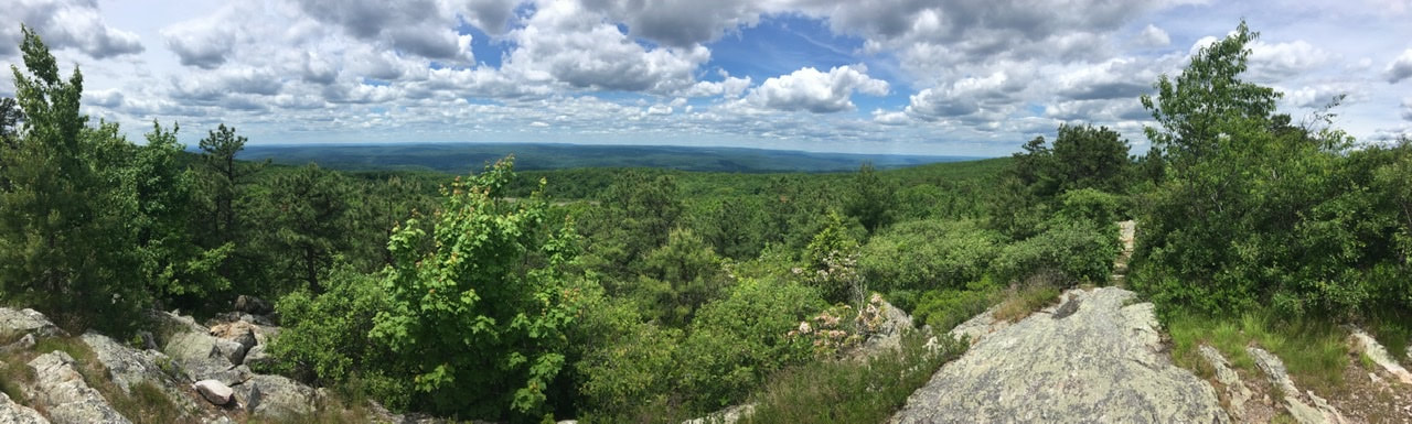 This one is for Mom. I played up the distortion that is imparted into panoramas for maximum nauseating effect. View from Rattlesnake Mountain. A mile and a half after Rattlesnake Mountain is the peak of Blue Mountain. This one is a bit grassier at the top, but also has nice views off to the northwest. 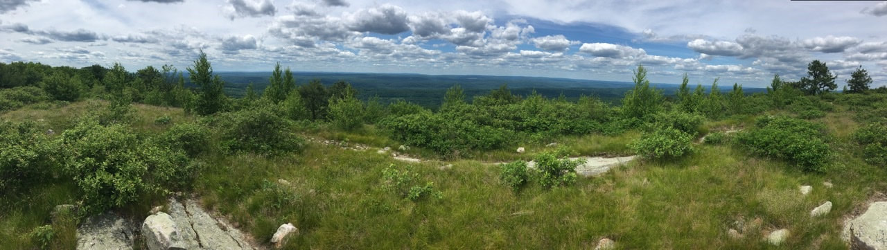 View from the summit of Blue Mountain A little over a mile north of Blue Mountain is another dry beaver pond. I'm beginning to wonder if New Jersey has an infestation of French trappers. This dried out pond was less creepy than the first.  Wh Two miles north of this old beaver pond is a nice view point overlooking Culver Lake. I had intended on getting a day's resupply here. Since I'm running late, and can certainly make it to Unionville with what I'm carrying, I decided that the 3.4 mile round trip to resupply wasn't worth it.  Culver Lake Regardless, the view down to the lake wasn't affected by my decision to not go into town. Between the Culver Lake viewpoint and the next overlook is about 3 miles - the longest distance in between excitement of the day's trek. This vantage point provided more views of a sea of trees. Such views never grow old! 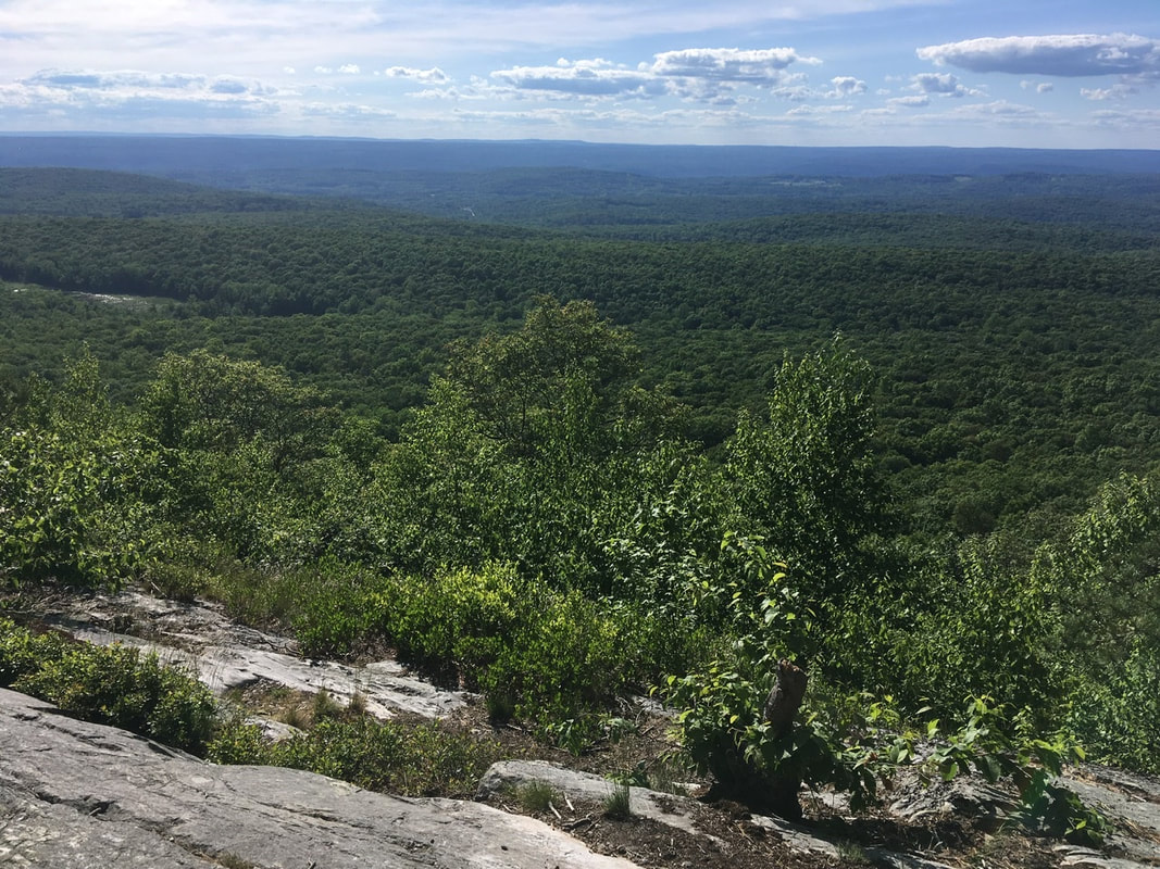 A sea of trees A short distance after that viewpoint is a fine tower. It looked to be inhabited, so I didn't go up to check it out. The views from this location are however nearly identical to those of the previous viewpoint. So, I didn't linger too long.  Culver fire tower About 15 minutes after the fire tower, I met my second smol fren of the day, this guy took the form of a wood frog. I was nice and quiet, so he paid me back by posing nicely for my photographs.  Wood frog A half hour after meeting Mr. Wood Frog I arrived at Gren Anderson shelter. I pitched my tent, made my bed and decided to wash my feet, legs, arms, and face in the small stream. That felt so good that I decided to do some laundry before sifting down for dinner. All-in-all a very productive day today. Exactly the opposite of yesterday! T+16 (June 14, 2020) Navigation Report: starting Point: Campsite @ 1305.9 Destination: Campsite @ 1312.7 Travel Log: Break Camp (mile 1305.9) 11:20 Yard's Creek (mile 1306.6) 11:45 Leave Yard's Creek 12:00 Kittatinny Ridge (mile 1307.7) 12:55 Catfish Fire Tower (mile 1308.9) 1:45 Millbrook-Blairstown Rd. (mile 1310) 2:20 * Rattlesnake Spring (mile 1309.5) 2:40 Leave spring 3:00 Arrive at beaver pond (mile 1310.3) 3:15 Depart beaver pond 3:25 Powerlines (mile 1310.6) 3:35 Campsite (mile 1312.7) 4:55 Daily Mileage: 6.8 Total Mileage: 164.1 Commander’s Report: I totally wasn't feeling it today. I initially woke up at sunrise because I had to go pee. After doing my business I figured I would go back to sleep until maybe 6:30. Instead I woke back up at nearly 9AM. The rest of the day went similarly slowly. I know it is because my brain is still down on the whole "not a thru-hike" thing, but my brain can go fuck itself. I'd like to enjoy what time I get on the trail, thank-you-very-much! After breaking camp, it was a short hike to Yard's Creek. I stopped briefly here to filter some water to carry me through the day. Tonight is again going to be spent at a camp without water, so I'll have to get water in the afternoon before arriving at camp. The first attraction of the day is Kittatinny Ridge. The first view was off to the northwest and was partially obstructed.  View northwest from Kittatinny Ridge The second viewpoint was spectacular! It featured rock formations arranged like stadium seats overlooking the views southeast. As a bonus, there was a tree providing this pasty assed white boy shade so I could enjoy the view - like a boss. 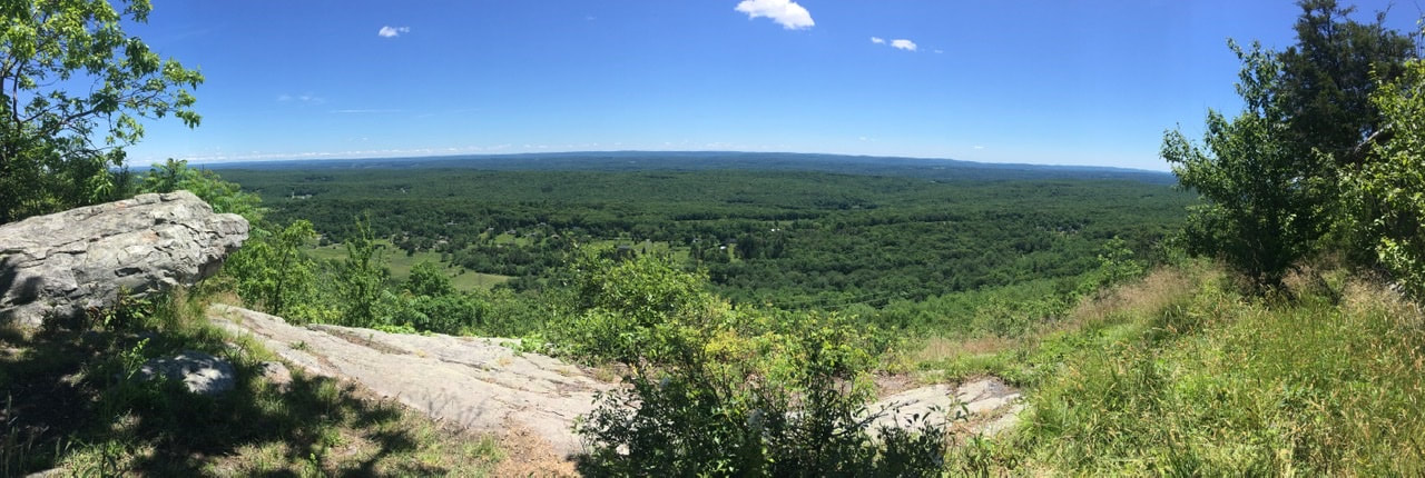 The trail follows the ridge for quite a way with intermittent views, but no spot as good as the amphitheater. 1.2 miles north I passed up an old fire tower. I would have taken some pictures, but there was a gaggle of teenagers climbing it. A bit over a mile north of the fire tower I crossed Millbrook-Blairstown Rd. As part of crossing this road one has to walk for a couple hundred yards on the side of the road-around a blind S turn. Not ideal! Less ideal is the fact that I forgot to get water for camp at the last (acceptable) water source. I made a mental note in the morning to stop at Rattlesnake spring, but when I arrived there and consulted the map I forgot that the next two water sources were, respectively, runoff from a swamp and runoff from a beaver pond. A big nope on both those fronts. So, I backtracked 0.6 miles (each way) to get water from the spring. Once I managed to get my shit together I continued on past Millbrook-Blairstown Rd for the second and final time. Shortly after the road is a HUGE beaver pond. It probably encompasses 10 acres of land and has not one, but two beaver huts in the middle. I was under the impression that a single family of beavers occupied a pond at a time. Perhaps one of the huts is an old, disused one.
After climbing up from the beaver pond the trail crosses some power lines, which provided a nice view.  Power lines always provide a good view Just a short bit after the power lines is a view point that provided an alternate angle of the cut in the forest made for the power lines. 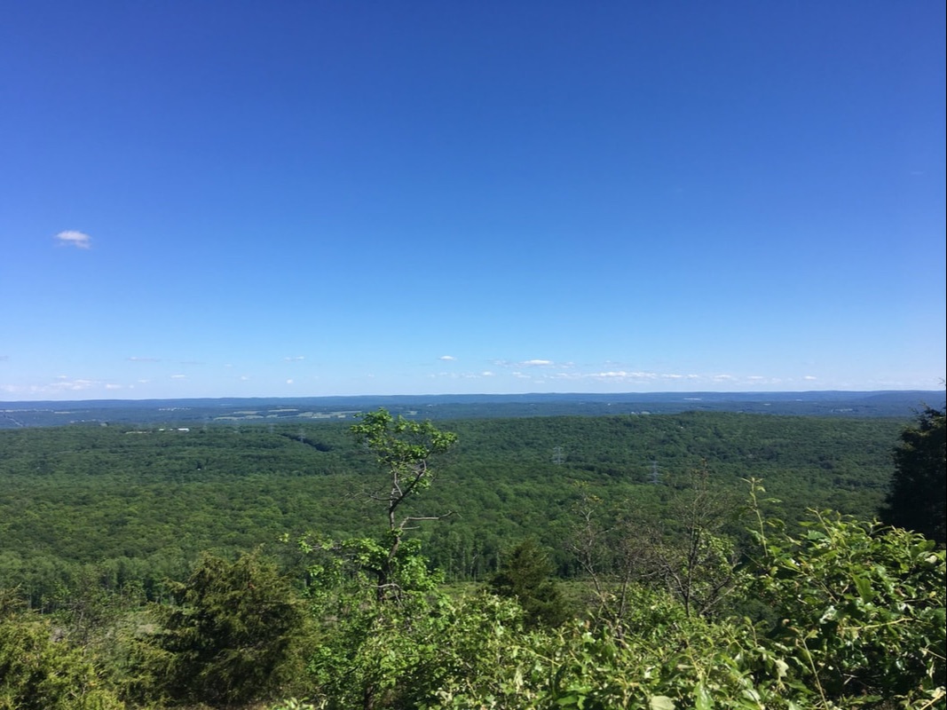 I don’t know about a river. Power lines run through this picture. Between the power lines and the campsite was a thicket of beautiful smelling flowers. I used the SEEK app and discovered that these are roses. It makes sense, given the thorns. However, I've never seen five petalled roses before. 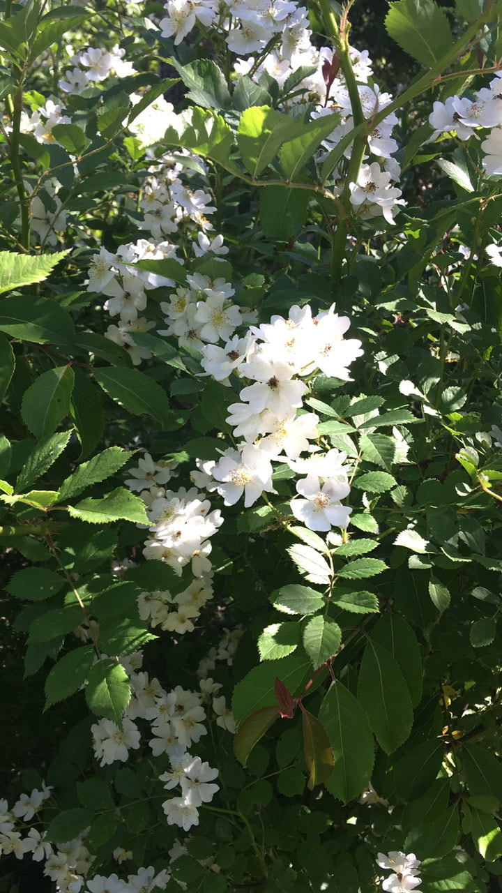 Wild roses From there, I continued down the trail to camp. It's not where I intended to make camp. The late start, combined with my slacking off (not writing up T+15, instead enjoying the fire and sunset) means that the extra 4.2 miles just isn't the cards tonight. On the plus side: the sunset view from my tent didn't suck one bit!  Just before sunset...from the comfort of my tent. T+15 (June 13, 2020) First day back on the trail after the COVID shelter in place period. Looking back it appears that I never properly wrote up T+14. It happened, but I can't be bothered to write about it. I guess I'll just move on. Navigation Report: Starting Point: Delaware Water Gap (mi. 1296) Destination: Campsite @ mile 1305. 9 Travel log: Depart Delaware Water Gap (mile 1296.0) 10:30 Arrive at Sunfish Pond (mile 1301.5) 12:40 Viewing Point (mile 1303.0) 1:30 Arrive at stream (mile 1303.2) 2:00 Depart stream (mile 1303.2) 2:20 Power lines (mile 1303.8) 2:40 Raccoon Ridge (mile 1303.9) 2:55 Viewing Point (mile 1305. 1) 3:40 Campsite (mile 1305.9) 4:00 Daily mileage (T+14) = 4.7 miles Daily mileage (T+15) = 9.9 miles Total mileage = 157.3 miles Commander’s Report: So, I'm back on the trail after a 10.5 week quarantine break. A bit of mixed emotions this time around. I'm excited that able to get back on the trail, but at the same time I'm quite bummed that I won't be able to complete the through hike. Gonna have to get over that. More days like today would go a long way toward-moving on! It was a beautiful day for hiking! Temps in the mid 70's with clear skies. It doesn't get any better than that! Unfortunately, all of NYC got the memo and decided to enjoy the outdoors. Can't say as I blame them. There were so many people that I didn't bother removing my mask until Sunfish Pond - 5 miles in. Even then it was a game of moving it from my neck to face every few minutes. The further I got from Delaware Water Gap, the fewer the people I encountered - definitely a plus in my book. The first attraction of the day was Sunfish Pond (mile 1301.5). It's a picturesque little glacial pond, which has been designated a National Natural Landmark. 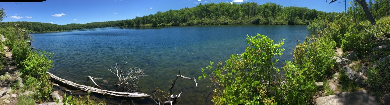 Sunfish Pond as seen from the south The designation means that there is no swimming allowed in the pond. With beaches like this I'd say that's OK.  The white sandy beach of Sunfish Pond After Sunfish Pond the trail continues upward and near the top of the ridge is the first partially obscured view (mile 1303).  Delaware River as seen from above Sunfish Pond A bit after that, there is a small stream (mile 1305.2) with the last water I'm able to access before camp. So, I filled my tummy and water bottles up. I also ported ~1L of unfiltered water with me. The water is quite brown and there's a bunch of organic material in it, but hey that's what a filter is for. Right? (Turns out the water was still brown after filtration, but it tasted OK.) Less than a mile after the stream is first some power lines and then the top of the ridge. The power lines had decent views, but the star attraction for the day was the view from Raccoon Ridge (mile 1303.9). You get nearly a 360 degree view of the surrounding country. Here's a panorama of the northwest view. That's the Delaware River. 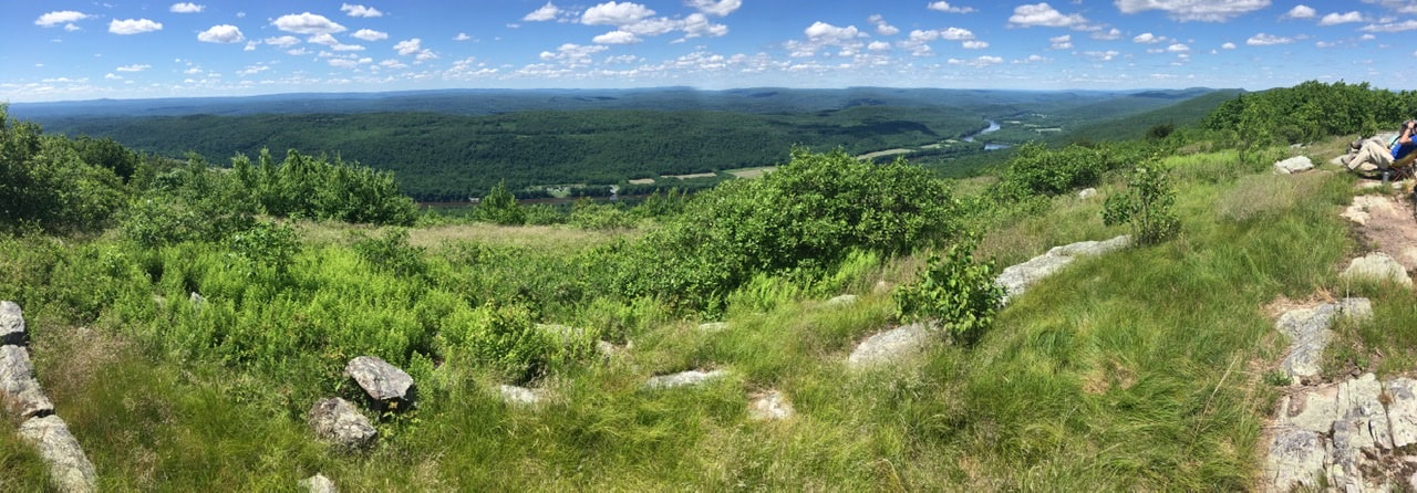 The view northwest from Raccoon Ridge The views of the southeast are equally nice. Instead of the Delaware River, there's Yard's Creek Reservoir instead. 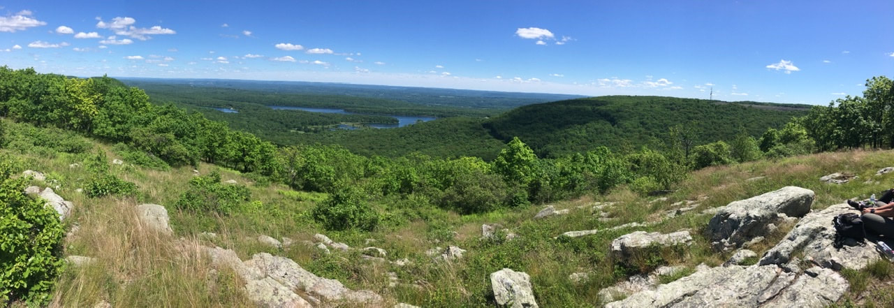 The view southeast from Raccoon Ridge After Raccoon Ridge viewpoint it is a mostly flat 2 mile hike to camp. Along the way is another view of Yard's Creek Reservoir. Made it to camp EARLY. Set everything up and ate dinner. As I had to pick up several downed branches from the tent site and there was a fire pit, I decided to make a small fire. It burned until after sunset, at which time I scattered the coals to hasten the fire going out.  Fire at campsite Speaking of sunset, I'll leave this here. It's obscured by trees, but pretty nonetheless.  Sunset from viewpoint at campsite I'm happy to announce that I'll be getting back on the trail tomorrow (Sat. June 13th)! The plan is to start at Delaware Water Gap (mile 1296.0) and head north to Katahdin. Easy peasy, right? We'll see! (Yes, this means I won't be thru hiking this year. I'm still toying with the prospect of heading to southern PA if I make Katahdin so as to complete 1/2 of the trail, but it's a big ask to have Mrs. Tedward keep shuttling me everywhere and I have to actually finish the first chunk first [NBD].) I envision a problem with this though. Like most everyone else, during quarantine I've hardly moved. Forget 10,000 steps, some days I'm lucky to get 10 in! One thing pointed to as being a benefit of hiking northbound is that the first half of the trail prepares you for the rigors of hiking in VT, NH, and ME. Perhaps I have a small leg up in being familiar with that terrain, but that'll only get you so far in an out of shape body! I worry that the ~300 mile trek to Mount Greylock won't be enough to prepare me for the serious elevation changes that come after Mt. Greylock. Also, I don't think I'll be able to do as many miles per day as I was pulling off earlier this year. So I've done something I absolutely hate doing: I've planned the first 17 days of my restart. I prefer to be freeform about such decisions, but I also know that I will totally push myself too hard too fast after such a long layoff. So, I planned it out and I intend to stick to it! 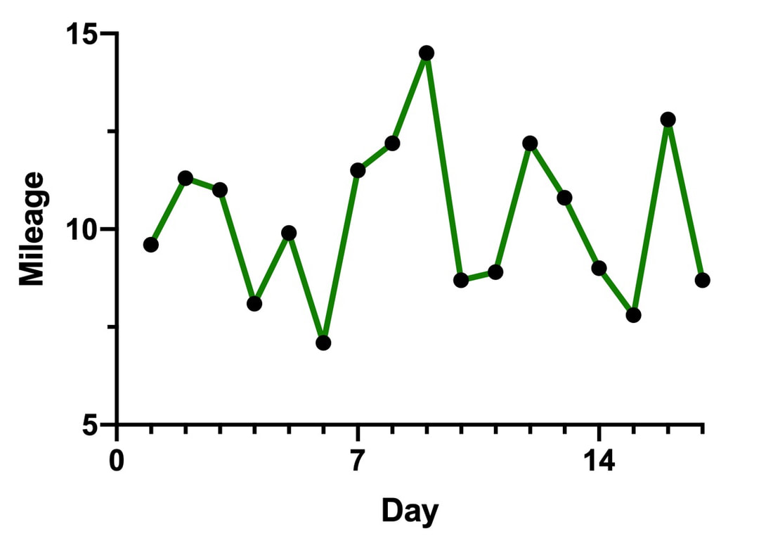 I am planning on keeping the first week to about 10 miles per day. There's going to be a bit of variation based on camp site availability, but the 7 day average is 9.5 mi/day. The second week I'm going to be bumping that average up a bit to 10.9 mi/day. In essence, I've planned out a 174.1 mile section hike between Delaware Water Gap, PA and Kent, CT.
I also kept in mind to surround longer day(s) with easy ones. For instance, on days 7, 8, and 9 I'm scheduled to do 11.5, 12.2, and 14.5 miles, respectively. Before that stretch I planned the easiest day (7.1 miles) and two sub-9 mile days after it. Before you hit the comment button about my equating mileage with difficulty, keem in mind that I'll be traversing the NJ, NY, and southern CT section of the trail during these 17 days. It's an easier section of the trail with only 33,680' of elevation change total. Before reminding me that terrain matters, please compare that to the 175 mile sections between Mt Greylock and Etna, NH (42,300') or Etna, NH and Grafton Notch ME (57,360'). Anyways, I'm hoping that all this preparation will save me from myself. I know I'm going to start off with apparel that may be on the hot side of acceptable for this time of the year. Thus, I'm planning on leaving my super warm down jacket behind. I'm expecting I'll be making changes to my apparel as I get to MA/VT, so that's something I may have Mrs. Tedward send me in one of the mail drops. Speaking of mail drops, I had planned out 6 mail drops This discussion of trail nutrition comes on the heels of my gear shakedown post. What you bring with you and what you put into your body are the two main variables that one can control in the woods. While I feel like I got the gear 85% correct, I failed pretty spectacularly on the nutrition front. Over the course of 14 days on the trail I managed to lose 5 pounds. That would be great if I were overweight and actively trying to shed the pounds, but I started off at 150 pounds so there wasn't much to lose to begin with. Clearly that burn rate was entirely unsustainable!
Let's do some math in order to help understand what I need to change for when I get back on trail: 1 pound of fat = 3,500 calories (approximately) 5 pounds of fat = 17,500 calories (17,500 calories) / (14 days on trail) = 1,250 calories per day That would be an additional 1,250 calories a day (at least) that I need to consume in order to help keep on the weight. Likely I need between 1,500 and 2,000 additional calories daily. That's because included in those 14 days are two half days of hiking and a day that I wasn't on trail at all. So, the denominator should be more like 12, which would yield 1,459 calories per day. Let's go with an increase of 1,500 calories per day. That brings us to the question: "What I was consuming each day while on trail?" Obviously, I had a different menu every day on the trail. There were, however, consistencies in my daily diet. Plus, the calorie count for most of the meals were fairly similar, so plowing ahead should get me a rough idea of where I was. Breakfast: 2 packets flavored Quaker Oats 320 cal 1 black tea 2 cal Lunch / Snacks: 3 granola / protein bars (~180 cal each) 540 cal 1 oz beef jerky 120 cal Dinner: Backpacker meal 500-700 cal OR one of the following: Mashed potato side 440 cal Rice side 450 cal Couscous 570 cal WITH precooked chicken 80 cal Breakfast 325 Lunch 660 Dinner 650 Total 1635 Holy freaking moley! I was running a deficit for a normal 2000 cal / day daily intake while strenuously exerting myself. I was running on 1/2 the required calories, no wonder why I lost so much weight!! I feel like a total dolt for not doing the bean counting before now. I have done lots of hiking before and had similar menus so didn't give it much thought. Of course, day hiking or overnight camping excursions almost invariably ended with a large restaurant meal on the way home OK, so let's take a crack at reconceptualizing a daily trail menu that meets the required 3250 calorie intake. I like the oatmeal packets for breakfast, but the calories are just not there. And of the calories that are there, 1/3 are from added sugars. To make matters worse, I feel unproductive if I spend too much time lingering for snacks during the day, so I'm definitely going to have to juice things up for breakfasts. Surely, I can do this with items easily found in small town grocery stores. Breakfast 1 c. instant oatmeal 300 cal 1 packet Carnation Breakfast Essentials 220 cal 2 oz raisins or dried cranberries 175 cal 2 tbsp honey 120 cal Now then, that's more like it! An 815 calorie breakfast oughta go pretty far. As for lunch, I think I'm going to stick mainly to the granola bar approach. I know I should be taking it easy out there, but I feel unproductive lingering about preparing a proper meal in the middle of the day. I'll probably be going with 2 granola bars, a meat product of some sort, and GORP. Lunch 2 granola bars 360 cal 1 oz beef jerky 120 cal 1/2 c. peanuts 365 cal 1/2 c. raisins 228 cal Adding in a cup of GORP really helps up the on-trail calorie intake. I'm up to 1073 mid-day snacking calories. As it is looking more and more like the opportunity to get back on the trail will present itself sometime this summer I have decided to do a post on alterations to the kit I will be bringing with me if/when I get back to hiking. As part of that, I have updated the Equipment page to reflect the changes.
Subtractions: Camp Chair I absolutely loved the little NiceC chair! I've got terrible back problems and being able to sit in this after a day of hiking felt like relaxing in an EZ Chair. The problems: the thing weighs nearly two pounds (dry), cannot be stored inside my pack, is only worth getting out when dry, and absorbs ALL THE WATER during the rain. I tried ameliorating the last part by putting it in a cuban fiber dry bag, but that only delays the inevitable. Replacement: I may be replacing with a sitting pad, but I haven't convinced myself of this yet. Cold Soak Container I thought that the Cnoc bag would be a nice alternative to using a peanut butter or Talenti jar for cold soaking. The jars take up a bunch of otherwise usable real estate in the pack when not in use, while the bag takes up almost no space at all. The bag was worth it for that aspect of things. The problem: The bag was nearly impossible to clean! I prepared a spicy dinner in it once and despite several washes with soap and water the thing still smells of that dinner. It made for really interesting oatmeal breakfasts when I was without fuel. Also, the shape made it impossible to truly clean out the nooks and crannies of the container. Replacement: I will not be carrying a dedicated cold soak container. Rather, I will use a tight fitting silicon top to turn my titanium pot into a sealed container suitable for cold soaking. Changes Rain Gear I harped on this several times in my daily blogs, but I'm going to do it again here. The Frogg Toggs rain gear was the single biggest fail of the equipment I brought with me. The jacket wasn't all that bad. It's a bit oversized for my slight frame and once I realized how delicate the material is I avoided tearing the seams when adjusting. The problem: I would consider my hiking gait as "controlled stumbling" in the best of times, double so in wet/icy conditions. This means I regularly bump my shins and knees on rocks while hiking. This isn't a problem normally, but the Frogg Toggs pants got absolutely destroyed because of this type of wear. Also, I didn't like the restrictive feeling of the additional layer of pants. Replacement: I am going with the gear I wanted before setting out initially – Zpacks Vertice rain jacket and skirt combined with gaiters. I was reluctant to pull the trigger on these due to the cost, but decided it was probably the right call in the long run. Combined, these weight a bit more than the Frogg Toggs. Much of that is the gaiters, but I fully expect to change my mind as to their usefulness after a few uses and end up shipping them home. Pillow I think I about nailed my sleeping setup for the hike. In spite of the chilly weather, I was quite warm while sleeping. Also, I managed to get the best sleep I've ever had while camping. The problem: At the last minute, I decided to bring my old Kelty Camp Pillow on the trail. It's essentially a mini pillow like everyone has at home, so doesn't pack down very compactly and can quickly get quite damp. I am a side sleeper and was using this pillow in between my knees, so it's dispensable as I can use some of my clothing for this purpose but that's not quite as comfortable. Replacement: I will be trying to use a medical-style inflatable pillow for between my knees. These are super cheap, lightweight, and if it doesn't work well I can always go with clothing in a stuff sack as plan B. What Worked / Gear Reviews: I won't be getting into everything, but I did want to make some comments about some of the critical gear. Pack I've found the Zpacks Arc Blast to generally be a super comfortable pack - in spite of buying it with a hip belt too small for me. Packing up a single opening bag does take a bit more planning than the compartmentalized ones, but I got the hang of that. I only wish I have is that the mesh front "compartment" held a bit more stuff. Tent The Zpacks Duplex is just perfect for my needs. It's long enough for me that I'm usually not bumping my head or feet on the ends of the tent and getting them wet. It's spacious enough to get entirely ready for a day's hike before jumping out into the weather. The only complaint I have is the difficulty in getting a good pitch in super rocky soil, but I knew this would be an issue with a non-freestanding tent. Quilt (Sleeping Bag) Because I am a side sleeper and tend to toss and turn during the night, I went with a quilt instead of a traditional sleeping bag. Apart from the foot box, quilts don't have a bottom to them. Rather, they attach to your sleeping pad and form a pretty tight seal to keep the air out. This prevents the bag from getting all tangled up around you as you toss and turn - which I have certainly found annoying in the past. Also, I got the bag with the most filling as I am a really cold sleeper. In every aspect, the Enlightened Equipment quilt I got has been perfect for me. "Waterproof" Socks and Gloves I thought these were silly when I first heard of them. I mean, how can such clothing be waterproof? Truth is, they aren't really waterproof. But, they do a really good job of keeping the water out. It takes several hours of constant rain for the gloves to completely soak through. And even when they've soaked through they still provide quite nice insulation because there isn't a very fast turnover in the water, so you're body isn't trying to continuously warm up new cold water. I'm definitely taking these back out on the trail with me! Injinji Toe Socks These were another late addition to my kit. They're highly touted for helping to prevent blisters, but I kind of assumed that I would find the toe socks super annoying. I have to say I didn't really notice them at all and while I did get a single blister, I think that had more to do with me pressing too hard before my body was ready. I'll be continuing to use those little guys. Power Bank Choosing which battery bank to take with me was a tough decision. I didn't really know how much additional juice I would need on the trail, so in the end I did what I normally do and planned for the worst case scenario. I brought the biggest power bank available with me. Turns out that is a perfect amount of juice for 5-7 cell phone charges, 1+ iPad charge, and ~10 headphone charges. So, exactly perfect for 5 days in between charges. So, in spite of the heft of the thing it'll be going back out with me. Clothes I was really satisfied with the layers I brought with me. They were perfect for the weather I experienced (20's-60's, rain, freezing rain, and sun). The thing I am worried about for the summer months (assuming I get out there for summer) is that the puffy jacket will be too warm for what is required during the summer. Also, I am looking into switching out my hiking pants. They're a bit too big as I've lost weight since buying them and how they rode on my hips contributed to the discomfort of my pack belt. But, I really need to try potential replacements on before pulling the trigger...so these probably won't get replaced before getting back on the trail. Sorry for the long gap between posts. I've been actively avoiding writing this one as the decision to get off the trail is wrapped up in my mental health and I haven't really been feeling up to discussing that. But I'm going to give it a shot today. This is likely to be a long one, so strap in.
While on the trail I had little time or opportunity to fully keep up with the news. I'd catch snippets of what was going on, but I wasn't religiously following the news. So, the decision to get off the trail was made pretty much the evening of March 31st – about 15 hours before I got off trail. This decision was precipitated by an email I received from the ATC stating that they were going to be requesting temporary closure of the trail April 1. While exploring the links provided in the email I discovered that the shelters I had been staying in were officially closed, and had been for a week. I forwarded the email to my wife and discovered that she was only really available to pick me up April 1. So, the 20 mile day I had just finished turned out to have been a good strategic choice. It put me in position to make it into Duncannon early the next day without embarking super early or turning it into a sprint. So, the choice to get off the trail was more or less made for me. This was probably for the best, as I don't know if I would have made the decision of my own volition. That reluctance to do the wise thing comes down to the reason I was hiking the AT in the first place. The trek was meant to be a mental restart after years of neglecting my mental health had left me in a very, very dark place. Mrs. Tedward and I had been living apart since 2011. Both of us have been pursuing scientific careers in academia and there just hasn't been the opportunity to reunite. In 2014 I was leaving my first postdoctoral position and tried finding a position in her area but failed. At that time my mental health was shaky at best, but with the new position came a renewed vigor. I've been dealing with anxiety and depression since I was a teenager and up until last year I had told maybe 3 or 4 people about this. Forget about seeking therapy or treatment - that was just not in the cards. My strategy was to throw ever more of myself into my work, which proved a very effective coping strategy for me over the course of many years. Sure it comes at the cost of relationships and time with friends and family, but considering I get all worked up when meeting up with friends anyways it seemed a win-win. The second postdoc started off pretty awful with a project that time after time proved overly technically challenging. But a year and a half in, a new project pretty much fell in my lap and things immediately clicked. Again I had a renewed vigor and spent the next year and a half riding a big wave. Then in 2017 I started putting in applications for faculty (professor) positions. For those of you outside academia how this works is that universities usually advertise positions between Sept. and Dec. of one year for a start date in Aug. or Sept. of the following year. Candidates submit a big application package and wait for weeks or months to hear if they get a chance to interview either by Skype/Zoom or in person. If one is lucky enough to make the first cut and you impress them enough then there is a second round of interviews a month or two later. After that offers and negotiations (I never made it that far). If one doesn't get offered an interview, it's usually: ::crickets:: During my first round of applications in 2017, I told everyone that I was only going to pursue this path for two years. I was fairly confident that something would pan out in two application cycles and suspected my mental well being wouldn't make it much past that if nothing came of the first two tries. Things went decent the first round of applications: I got a handful of interviews and some interest, but nothing panned out. What I hadn't counted on was how much stress the whole process would give me and what coping mechanisms I would employ to deal with that stress. Suffice it to say that every step of the process was agonizing for me, and I found that my strategy of dealing with the stress was to spend even more time and effort in the lab conducting research. I virtually stopped hanging out with friends and my wife and I visited each other less often. By the second year of applying I was at the stage of depression where everything, even some days getting out of bed, seems to a huge task. But there still appeared to be some hope, so I was able to power through and be reasonably productive. Then in the middle of 2019, after a year and a half of working the job market, everything dried up. No more leads. Done. Fini. I knew in my heart that was it – there was no way I could manage another year on the same trajectory and survive. By mid 2019 the depression had progressed to the point where I had a hard time doing literally anything outside of lab. Making matters worse, my brain was no longer in the game when I was in the lab, so many of my experiments failed due to operator error. I hated myself, my predicament, and felt entirely impotent to navigate an exit strategy. Also around that time serious thoughts of suicide became near daily occurrences. Again, I've dealt with that since I was a wee lad, but this was the worst it had been since I was a teen. I never had any specific plans, but my depression has always kept my ability for long term planning to a minimum, so I knew if I were ever to do the deed it would be spontaneous - in a fit of rage. One trick I had found years ago worked to snap me out of the suicidal thought pattern was self-harm, specifically hitting myself upside the head. As the downward spiral progressed, the depression getting worse and the thought of suicide intensifying, the frequency and intensity of the self-inflicted corporal punishments increased. Things got so bad that I actually *started* seeking treatment. Now I say started there because it took nearly 4 months to get an appointment with a professional. Before I was able to make that appointment the thought of hiking the AT entered my head as a serious exit strategy. I was mentally incapable of pondering the thought of leaving the lab without something in place, but I was also incapable of doing the legwork required to find a position in my wife's neck of the woods. So it started as "I've always wanted to do this, why not now?", and progressed to researching and planning a thru-hike. This planning gave me some hope and helped at the very least put the breaks on the downward spiral I was experiencing. Just before getting an appointment with a therapist I decided to cash out some money from my retirement account to fund the thru-hike. This was a promise to myself that I would indeed be thru-hiking in 2020, the thought of which provided me something to look forward to and work towards. The months leading up to my departure from the lab were really rough and I had some terrible days, but looking forward to getting on the trail was indeed a bright spot that helped get me through the dark times. I did not experience thoughts of suicide for 12 of 14 days I was on the trail. I wouldn't say everything was sunshine and rainbows, but hiking is therapeutic in many ways for me and being on the trail was helping me process things. However, from the beginning the trip seemed pre-destined to be cut short and I knew that if forced off of the trail I would likely revert to my pre-trail mental state. I was largely successful at pushing those thoughts out of my head while on the trail by focusing on the necessary daily tasks. After I got off the trail I reverted to a mental state reminiscent of the worst days before I decided to hike the AT. I was now unemployed in the midst of the worst economic downturn since the Great Depression (hopefully this one won't go on as long!!), unlikely to be able to get back on the trail this year, and annoyed at being a virologist siting on the sidelines during a viral pandemic. It's taken several weeks, but I'm currently back to the numb, unmotivated, depressive state I was at before getting on trail. I'm optimistic that things keep progressing toward a more positive outlook. Finally, I need to thank my wife for her patience and understanding. I don't think I would be where I'm at right now without her! T+13 (Mar. 31, 2020) Navigation Report: Starting point: Yellow Springs Camp (mile 1174) Destination: Clark's ferry Shelter (mile 1153.9) [Fallback option: Peters Mountain Shelter (mile 1160.6)] Travel Log: Depart camp (mile 1174) 9:00 Rattling Run Creek; filter water (mile 1171.3) 10:15-10:30 Cross PA-325 (mile 1167.3) 12:30 10 miles from Clark's Ferry shelter (mile 1164) 2:30 Whitetail Trail (mile 1162.1) 3:00 Peters Mountain Shelter (mile 1160.6) 3:30 Arrive at Clark's Ferry Shelter (mile 1153.9) 7:10 Daily mileage = 20.1 Total mileage = 142.1 Commander’s Report: I got a very early start this morning: I awoke at 4:45, but I didn't want to accept that I had to get up until 5:30. Spent a bit too long working on writing up yesterday's report, so I didn't start packing things up until a bit before 8:00. I had everything set around 8:45, said “bye" to @thesunfishduo, signed the Yellow Springs log book and was off. I've noticed that a typical morning on the trail for me is generally slow going as I adjust my pack, shoes, pants, etc. So it was today, with the added complication of weather that was chilly, but too warm for my light outer layer when the sun emerged. So that outer layer came off, went back on, came off... It really slows things down to have to go in your bag every half hour. On the plus side, the military was doing some training flights over the area. So, I got to watch what looked to be A-10 Warthogs flying really low in circles around me. A couple of times they flew almost overhead. Moments like that turn me into a little kid. Even though I'm not a huge fan of the military industrial complex that produces them, one has to admire the engineering and impressiveness of the machine as an object in and of itself - rather than an instrument of death. Around 10:15 I stopped at Rattling Run Creek to filter some water for the day. Perhaps a mile and a half after that I came upon a junction with the Horse-Shoe Trail, which is not in my guidebook. So, I decided to check out the trail register for a minute. Seems to be getting some use, but the entries are spaced days apart - kinda like the shelter log books. 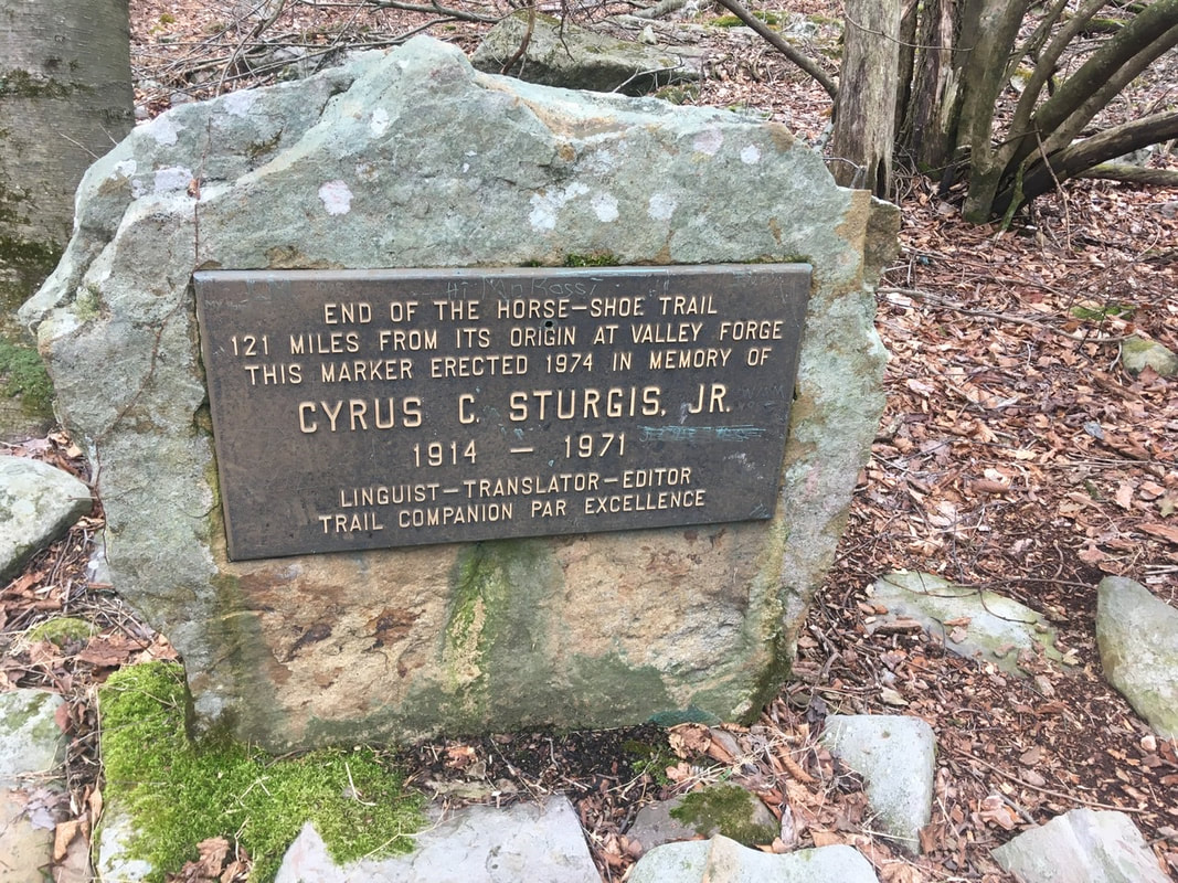 Marker at terminus of the Horse-Shoe Trail. In memory of Cyrus Sturgis, Jr. While I was checking that out, another hiker came up the trail northbound. Said his trail name is Yeti. Given his giant white beard, I'd say the name fits. He started last year in GA, but had to get off trail at Harper's Ferry. He's giving the remainder a go this year. Good on him, hope he’s able to make it to Maine! A ways down the trail I came across a spring running out of the mountain whose water was so loaded with iron that it costs everything it contacts with rust! I wonder if the mining operations I saw yesterday were going after iron. Coal seems likely too though. I'll have to look that up sometime. [Editing note: The Rausch Gap mines we’re going after coal, not iron.] 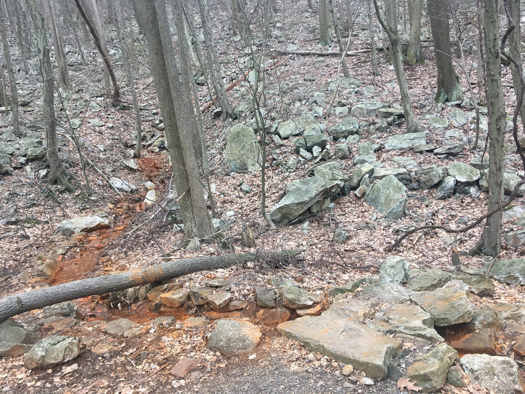 Iron spring Just a bit after PA-325 there's a stretch of land where all of the rocks are covered thick with moss. I've always enjoyed that aesthetic, and have been looking forward to the Smokies because much of the forest there is moss covered. The Smokies are a long way down the trail though! 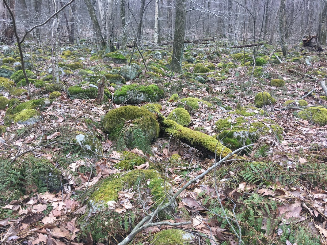 None of these are Rolling Stones, that’s for sure! Immediately after the short moss covered region of the trail is a nice little stream. I stopped here for a minute to take lunch. 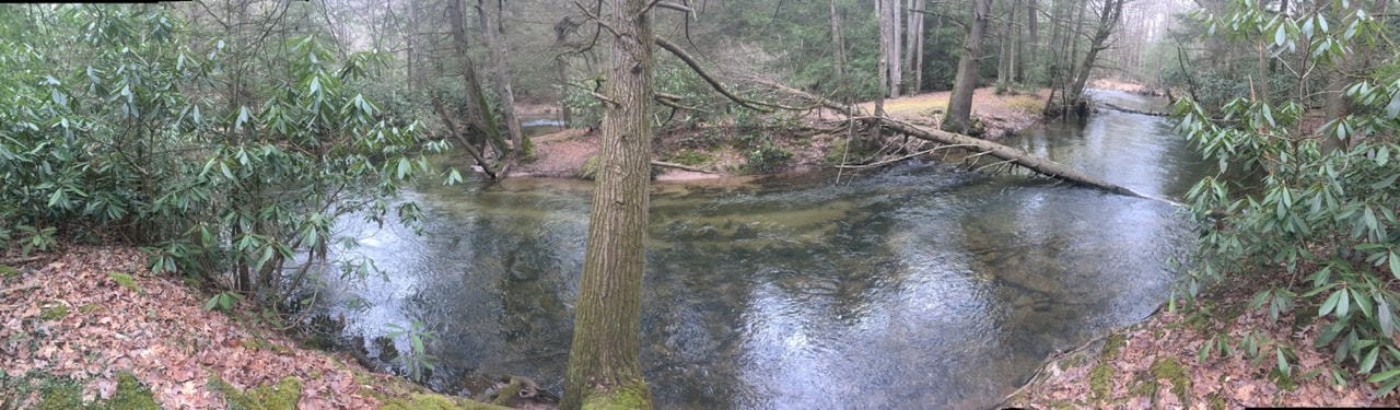 Wonderful little stream. If it were warmer I’d have probably bathed in it! Once back on the trail, I decided to make some phone calls to plan my resupply in Duncannon. First up: Kind of Outdoorsy. I heard from Ricky and Brian that this outfitter was still open and selling fuel canisters. Over the phone though the proprietor said that they were indeed closed, but provided options for procuring fuel canisters in the area. A couple calls later and I had arranged to meet someone in Boiling Springs to obtain two fuel canisters. Next up: lodging. I would like to spend the night in town to shower, dry equipment, and recharge batteries. For the fourth day in row, I was unable to reach the small hotel in town. I suppose they must be closed. I did get in touch with the Red Roof Inn (3.7 miles outside of town) and they're open. Unfortunately, they are not currently providing shuttle service to / from town. So, I guess that means I will be spending the night in Carlisle (18 miles further down) as the lodging options are much closer to the trail. That means I have to figure out a way to recharge batteries if I will be on trail an additional 2 days before I can get those fully charged. Supposedly Mutzabaugh's Market in Duncannon is hiker friendly and may allow me to charge my battery bank while I shop. It charges fully in 3.5 hours, so 30 minutes of charging will probably be enough to at least get my phone through until Carlisle. Around 2:30PM I checked Guthook (my GPS-based navigation App) to see my progress and discovered that I was only half way to Clark's Ferry Shelter. 10 miles down to miles to go. Back of the envelope calculation indicates an arrival at the shelter around 7PM. The old legs and feet are definitely getting tired though, which will definitely affect this calculation! At 3PM I passed the intersection with White Tail Trail, and around that time the weather rolled in. It wasn't forecast to rain today, so at first I believed it would just sprinkle for a bit and then pass me by. Unfortunately, that wasn't my luck. It sprinkled on and off for the next couple of hours. Nothing hard, just enough to soak everything through and be generally annoying. After the rain though, the cloud cover was lower than the elevation of the plateau / ridge - meaning another night sleeping in the clouds. It was also after the rain had set in that I got to the best view spots of the day. Unfortunately, it was quite overcast and drizzly when I captured the pictures. I guess it could have been worse: the ceiling could have dropped by then so all I could see is cloud!   At 3:30 PM, I FINALLY passed Peters Mountain Shelter, 6.7 miles left to Clark's Ferry Shelter. I lingered a while at the intersection leading to this shelter for a few minutes, both regretting my decision to go to the further shelter tonight and knowing that it’s the correct long-term decision. My feet are so sore, especially the right one. The injury sustained crossing the swollen Creek on T+10 has become a nagging source of pain. Every time I step on a rock or root such that the pressure is concentrated on the outside of my arch sends a shock of electricity through my leg and I have to stop and let the pain pass before continuing. I crossed Peters Mountain Road (mile 1157.7) around 5PM. It would have been a pretty dangerous crossing. in the past, but the local trail club installed a pedestrian bridge over the road. Much appreciated in my current exhausted state! For the rest of the 4.2 mile trip to the shelter my legs felt like they were made of overcooked spaghetti. I relied heavily on my hiking poles to keep me moving forward at any kind of reasonable pace. Also, my feet felt as if they had gotten caught under a steam roller (think Tom & Jerry style). Whenever I stopped for a breather it was really difficult to push past the pain to get back into a rhythm. The last mile or so felt as long as the first 19 combined! I was really cursing my decision to push this hard after less than two weeks on the trail! I was also cursing everything else, but it all stemmed from my decision to go 20 miles to the second shelter. Given the changes in resupply and sleeping plans I think it was the best option - in spite of the short-term pain. Just after 7PM I arrived at Clark's Ferry Shelter. It's an older one, definitely showing its age. It has a bunk bed set up on either side of the shelter and a ~10' square open area in the middle. First thing after arriving at the shelter: get my shoes off and give my tootsies a bit of a massage. In doing so, I discovered that the pain I was feeling on my pinky toe was the cause of a relatively large blister. I'll take care of that in the morning. Tonight’s for stuffing food in my tummy and getting some sleep!!  The big baby has another owie! |
About Me
Archives
July 2020
Categories |


 RSS Feed